
Carretera Austral
Puerto Varas a Villa
O´Higgins
ITINERARIO SUGERIDO - De Norte a Sur
Puerto Varas a Villa O Higgins.
Necesitarás tiempo para disfrutar de trekkings, kayak, pesca y otras actividades al aire libre.
Hemos diseñado este itinerario con algunos días extra.
SI QUIERES, PUEDES ACELERAR Y PEDALEAR MÁS RÁPIDO, O REDUCIR TU VELOCIDAD SI TUS PIERNAS ESTÁN DEMASIADO CANSADAS Y DESCANSAR UN PAR DE DÍAS.
TE SUGERIMOS PASAR ENTRE 25 A 30 DÍAS EN CARRETERA AUSTRAL.
DIA 0: Llegada al Aeropuerto el Tepual
El aeropuerto más cercano es El Tepual (PMC) en Puerto Montt. Todos los vuelos domésticos son operados por tres compañías aéreas locales: Latam, Sky Airlines y JetSmart. Es muy fácil conseguir transporte a Puerto Varas. Dos buenas compañías de traslados desde el Aeropuerto de Tepual son Turis Tour o Survip.
Ofrecen shuttles regulares y privados a Puerto Varas por $ 30.000 CLP.
Sleep this night in Puerto Varas, you can choose from a wide variety of cabins, hotels and hostels.
DAY 1: Puerto Varas to Caleta La Arena 66 km
To avoid the heavy traffic in Puerto Montt, we recommend taking a shuttle (private transfer) from Puerto Varas to Kilometer 0, where the Carretera Austral officially begins.
If you’d like, we can coordinate the shuttle for you and connect you with a trusted local driver. From there, you’ll ride through lush green landscapes and peaceful countryside roads as you pass by the breathtaking Alerce Andino National Park, one of Patagonia’s most beautiful rainforest areas.
If you’d like, you can take the ferry from Caleta La Arena to Caleta Puelche, your very first ferry crossing and the first of several unforgettable adventures along the legendary Carretera Austral.

DAY 2: Caleta Puelche to Hornopirén - 55km
After this short ferry crossing, you’ll arrive to Caleta Puelche, where your true Patagonian adventure begins. As you pedal south toward Contao, you’ll notice the landscape transforming around you — forests growing denser, the wilderness feeling deeper, and signs of civilization slowly fading away. After Contao, supplies become scarce and options are limited, often no more than freshly baked bread in small local shops.
Make sure you stock up well in Hornopirén, the last town with good infrastructure before entering more remote territories. Here you’ll find supermarkets, small stores, and local restaurants — a perfect place to rest and prepare. Hornopirén is also home to the Somarco office, where you can purchase your ticket for the iconic bimodal ferry that will carry you across fjords and pristine waters into Caleta Gonzalo, in the heart of Pumalín National Park. Our strongest recommendation: book your tickets at least 30 days in advance — these crossings sell out fast.
As you enter the rural area of Hualaihué, let yourself be amazed by the raw beauty of Patagonia: towering forests, untouched coastlines, and endless views over the sea. This unforgettable day comes to an end as you reach the small and charming town of Hornopirén, where nature and adventure come together in perfect harmony.

DAY 3: Hornopirén to Caleta Gonzalo- 10 km Bimodal Ferry
The Bimodal Route: A Journey Through Fjords and Forests
Today, your legs get a well-deserved break — you’ll only be cycling around 10 km — but your eyes and heart will be in full motion. This unforgettable day is devoted to the legendary Bimodal Route, one of the most unique and scenic crossings in all of Patagonia.
The adventure begins in Hornopirén, where you board the ferry for an extraordinary 3.5-hour journey through the interior of Chilean fjords. Keep your eyes open for marine wildlife and towering, untouched landscapes gliding past on both sides of the boat.
Once you arrive in Leptepu, the journey continues on two wheels. You’ll ride the 10 km stretch to Fiordo Largo, immersed in raw and wild Patagonian nature, surrounded by dense forests and silence. From there, you will take the second ferry for a 45-minute voyage to Caleta Gonzalo, the gateway to the breathtaking Douglas Tompkins Pumalín National Park — part of the largest private land donation for conservation in the world.
Back on your bike, the magic continues: pedal through lush evergreen forests, step into silence while walking among ancient Alerce trees, and follow a spectacular gravel road that weaves alongside crystal-clear lakes. This privileged path will guide you to your next destination and well-earned rest in the charming town of Chaitén.
This is not just a route — it’s a passage through one of the last true wildernesses on Earth.

DAY 4: Caleta Gonzalo to Chaitén - 56km
Hoy recorrerás unos 60 kilómetros, y aunque es un poco más largo que en días anteriores, el terreno es mayormente suave, con algunas colinas onduladas y tramos empinados ocasionales. Es todo de ripio, pero está bien mantenido y rodeado de naturaleza virgen.
Al salir de Caleta Gonzalo, pedalearás por el corazón del Parque Nacional Pumalín Douglas Tompkins. Esta parte de la ruta es un sueño: densa selva valdiviana, cascadas que caen por acantilados cubiertos de musgo e imponentes montañas cubiertas de verde.
DAY 5: A Day of Exploration in Pumalín Douglas Tompkins National Park
Today, time slows down and nature takes the lead as you immerse yourself in the heart of Pumalín Douglas Tompkins National Park, one of the most pristine and protected areas in Patagonia. This is a day to step off the pedals and into the forest, trading speed for wonder.
From Caleta Gonzalo, a network of breathtaking trails invites you to explore ancient Alerce trees, volcanic viewpoints, hidden lagoons and cascading waterfalls. You can challenge yourself with the hike to Volcán Michinmahuida, wander along the magical Alerce Forest Trail, or follow gentle paths that lead to crystal-clear rivers and remote beaches along the fjord. For those craving panoramic landscapes, the Cascadas Escondidas and Sendero Los Alerces are unforgettable experiences, while the coastal area of Playa Santa Bárbara offers a perfect spot to rest by the sea.
If you still have energy in your legs, take your bike for a scenic ride through the park’s quiet gravel roads, weaving between towering trees, rivers and lakes that seem untouched by time. Whether you hike, ride, swim, photograph or simply sit in silence, this is a day to reconnect with the wild spirit of Patagonia and with yourself.
In Pumalín, every step is a reminder that you are traveling through one of the last great wilderness sanctuaries on Earth.
DAY 6: Chaitén to Lake Yelcho, riding into a Postcard of Patagonia Distance: approx. 60 km | Paved Road I Elevation gain: approx. +500–600 m
Leaving Chaitén behind, you’ll ride south on a fully paved road that winds through lush green forests, wide rivers and dramatic mountain silhouettes rising on both sides. Today’s ride is both rewarding and deeply scenic — challenging enough to feel strong, yet smooth enough to fully enjoy the journey.
Along the way, you’ll pass through the small settlement of Puerto Cárdenas, a quiet corner of the fjord that seems frozen in time. From here on, stay alert, because one of the most iconic landmarks of the Carretera Austral is just ahead: the famous Lake Yelcho Hanging Bridge. Suspended above turquoise waters and framed by wild Patagonian landscapes, it’s the perfect spot to stop, breathe, and capture some unforgettable photos of your adventure.
As you continue pedaling, the breathtaking Lake Yelcho will slowly appear beside you, its crystal-clear waters reflecting the sky and the surrounding mountains like a mirror. This peaceful stretch is your invitation to slow the pace, take a deep breath, and start looking for a place to stay for the night — whether it’s a lakeside campsite, a cozy cabin or a rustic lodge on the shore. A refreshing dip in the lake, a golden sunset over the water, and the quiet sound of the wind through the trees will remind you that you are exactly where you are meant to be: deep in the wild heart of Patagonia.
This is not just a ride — it’s a journey into the soul of the Carretera Austral.
DAY 7: Lake Yelcho to Villa Santa Lucía Distance: approx. 40–45 km | Elevation & challenge: includes the climb over the infamous “Cuesta Moraga” approx. +400–500 m. Road: mostly paved.
Leaving the turquoise waters of Lake Yelcho behind, you’ll continue south along a mostly paved stretch of the Carretera Austral, riding through dense forests, rivers and dramatic mountain landscapes. Today’s ride is challenging enough to feel like an adventure, yet smooth and flowing.
The day begins confronting the climb over Cuesta Moraga: a steep, demanding ascent that tests your legs and resolve. It’s not for the faint of heart, especially with loaded panniers, but the view and the feeling of overcoming it make every pedal worth it.
This quiet, wild section offers a true sense of Patagonia’s magic. Every curve reveals new views, and the only sounds you’ll hear are your tires on the road and the wind in the trees.
By the end of the day, you’ll arrive in Villa Santa Lucía, a small and welcoming settlement where you can rest,
Al salir de Villa Santa Lucía, tómate un momento para reflexionar: este pequeño asentamiento se vio gravemente afectado por un devastador deslizamiento de tierra en 2017. El pueblo reconstruido se erige como un símbolo de resiliencia y recuperación.
DAY 8: Villa Santa Lucía to La Junta: Entering Aysén — Wild Roads & Living Memory Distance: approx. 70–75 km | Paved Road
From Villa Santa Lucía, you push southward into the rugged beauty of Aysén — a land where history and wild nature coexist.
As you descend towards La Junta, the landscape starts to shift: broader valleys, rivers fed by snowmelt, and — if weather and luck allow — glimpses of glaciers high above. In fact, in this sector you’ll begin to see the distant presence of the Yelcho Glacier, a silent giant in the mountains, hinting at the wildness that lies ahead in Aysén.
By the time you roll into La Junta, you’ve crossed more than kilometers — you’ve entered a distinct world. The air feels different, the forests deeper, and the mountains closer. Here you can rest, resupply, reflect on the day’s climb, and prepare for the next chapter of your Patagonian journey — deeper into the heart of Aysén.

DAY 9: La Junta to Puyuhuapi Waterfalls, Fjords and the Gateway to Queulat National Park Distance: approx. 45–50 km | Elevation gain: approx. +450–550 m | Road condition: paved
Leaving La Junta behind, you continue south on a mostly paved stretch of the Carretera Austral that flows through one of the most lush and dramatic landscapes of the entire journey. Dense native forest surrounds the road, with towering mountains, hanging valleys and powerful waterfalls appearing around almost every bend.
As you ride deeper into the wilderness, you’ll begin to follow the edge of the legendary Queulat National Park, one of Patagonia’s true natural treasures. High above the forest, the iconic Ventisquero Colgante (Hanging Glacier) rests between the peaks — a massive wall of ancient ice that feeds countless waterfalls and gives this area its unmistakable character. Even without leaving the road, you can feel the presence of glaciers, rainforests and raw, untamed beauty all around you.
The air grows cooler and more humid, and the landscape shifts into a mystical, almost tropical rainforest atmosphere — moss hanging from trees, rivers rushing through deep gorges, and mist dancing between the mountains.
As you approach Puyuhuapi, the scenery opens into a dramatic fjord framed by steep forested slopes. This small village, founded by German settlers, welcomes you with colorful houses, warm hospitality, and the chance to relax in the famous Termas de Puyuhuapi — the perfect reward after a day immersed in Patagonia’s wild heart.
This is not just another stage of your trip — it’s an unforgettable entrance into one of the most magical regions of the Carretera Austral.
DAY 10: Puyuhuapi to Queulat National Park: Glaciers, Trails & Wild Patagonia Distance: approx. 20–25 km | Road condition: paved
Today is a short ride in terms of distance, but an unforgettable one in experiences. Leaving the small fjord town of Puyuhuapi, you cycle along a mostly paved stretch of the Carretera Austral that gently leads you straight into the heart of Queulat National Park, one of Patagonia’s most iconic protected areas.
Once inside the park, the real adventure begins. A variety of well-marked trails invite you to explore this ancient rainforest and get different perspectives of the legendary Ventisquero Colgante (Hanging Glacier). You can walk through moss-covered forests, cross wooden walkways above rushing rivers, and climb up to panoramic viewpoints where the glacier hangs dramatically between the mountains, feeding waterfalls that plunge hundreds of meters down the rock face.
For an even more immersive experience, you can join a boat navigation on the Laguna de los Témpanos, taking you closer to the glacier and the floating icebergs that break off from its massive wall of ice. It’s a rare opportunity to stand face to face with a living glacier from the water — an unforgettable moment in your Patagonian journey.
After a day of exploration, hiking and awe, you can choose to return and finish with the ultimate reward: a relaxing soak in the hot springs of Puyuhuapi, letting the warm water ease your muscles as you look out toward the wild landscapes you spent the day discovering.

DAY 11. Queulat National Park to Villa Amengual: The Challenge of Queulat Pass Distance: approx. 66 km | Road condition: tough gravel climb → paved descent
Leaving Queulat National Park, you ride into one of the toughest — and most spectacular — sections of the Carretera Austral. The day begins with the legendary Cuesta Queulat, a long, demanding climb on rough gravel, with loose stones, potholes and constant gradients that will truly test your legs, your lungs and your patience. It’s a slow, technical ascent, but every meter you gain rewards you with deeper silence, thicker forest and that intense feeling of being far, far away from the rest of the world.
Mist hangs in the trees, waterfalls cut through the rock walls, and the rainforest closes in around you as you fight your way up the pass. This is pure, raw Patagonia — beautiful and brutal at the same time.
Once you finally reach the top and begin the descent, everything changes: From there, the road tips downward and the effort eases, but the challenge is not over yet.
The descent is still unpaved, with loose gravel and uneven sections, so focus is essential. Ride carefully, especially with fully loaded panniers, as the bike can feel heavier and less predictable on the rough surface.
By the time you roll into Villa Amengual, after roughly 66 km of effort, you’ll know you’ve conquered one of the most iconic and challenging stages of the entire route. It’s the perfect place to rest, eat well, and celebrate what your legs — and your spirit — have just achieved.
This is prime territory for spotting condors overhead and gauchos moving cattle on horseback.
DAY 12. Villa Amengual to Villa Mañihuales: Rolling Valleys. Distance: approx. 60 km | Road condition: paved
Leaving the quiet outpost of Villa Amengual, the Carretera Austral leads you south through wide valleys, dense forests and open Patagonian landscapes. This stretch is mostly paved, offering a smoother and faster ride than previous sections, but still filled with rolling hills that keep your legs working and your heart pumping.
As you ride, the scenery opens into broad valleys framed by endless mountains and native forests of coigüe and lenga. The air feels fresh and pure, and the sense of solitude is constant — just you, the road, and the wind. Occasional rivers and streams appear alongside the route, adding to the wild beauty of the journey.
By the time you arrive at Villa Mañihuales, a small rural town surrounded by forest and mountains, you’ll feel deeply connected to the land you’ve crossed. Here you can rest, find basic services, restock supplies and enjoy a quiet Patagonian evening before continuing your adventure south toward Coyhaique.
This is a peaceful but powerful stage — a reminder that the magic of the Carretera Austral isn’t only in its challenges, but also in its endless open landscapes and stillness.
Today you ride into one of the most important stops on your journey: the regional capital of Coyhaique. It’s a long ride — about 85 kilometers — but the reward is big: a rest day in a lively Patagonian town.
There are two ways to continue south from Villa Mañihuales toward Coyhaique.
The first option is to stay on Route 7 through Villa Ortega and continue directly to Coyhaique. This is the classic Carretera Austral route, this is a gravel road, passing landscapes linked to Reserva Nacional Mañihuales and following the scenic Río Mañihuales.
The second option — and one we often recommend — is to head west to Puerto Aysén and then ride east on paved Route 240 toward Coyhaique. It is only slightly longer, roughly 15 to 25 kilometers more, but offers a smoother and faster ride. Along this road, you’ll follow the beautiful Río Aysén, pass through the iconic Túnel El Farellón, and later rejoin Route 7 near Coyhaique, where Laguna Verde appears on your left.
We always recommend staying two nights here:
Time to restock supplies, withdraw cash, and enjoy the region’s main city before heading deeper into Patagonia.

DAY 13. Villa Mañihuales to Puerto Aysén: From Forest to Steppe in a Sea of Purple Distance: approx. 60 km | Road condition: paved
Leaving Villa Mañihuales behind, the Carretera Austral takes on a completely different personality. The dense rainforest slowly fades, giving way to wide, open landscapes — the beginning of the Patagonian steppe, where the horizon stretches farther, the skies feel bigger, and the land opens into rolling fields and grazing lands.
This section is fully paved, allowing for a smooth and flowing ride. Along the way, you’ll begin to see the dramatic peaks of the Torres National Reserve, their rugged silhouettes rising like stone guardians over the valley. These mountains, sculpted by time, ice and wind, dominate the scenery and remind you of the immense geological forces that shaped this land.
One of the most beautiful surprises of the day is the explosion of purple lupine flowers that paint the roadside and valleys in vibrant color during the warmer months. These wild blooms stretch for kilometers, creating one of the most striking visual contrasts of the entire Carretera Austral — deep purple fields against golden grass, blue skies and snow-capped peaks.
As you continue riding, you’ll pass by natural highlights such as Laguna La Esponja, a quiet and lesser-known body of water hidden among the rolling hills, and the impressive Monte Colmillo, which rises in the distance as both a landmark and a silent companion on the road. The landscape feels vast and exposed now — pure Patagonian steppe, dotted with ranches, fences and endless grasslands.
Approaching Puerto Aysén, the land begins to descend again, and the greenery slowly returns. The town sits near the Aysén Fjord, surrounded by quiet rivers and forests, offering a perfect place to rest, refuel and enjoy a peaceful afternoon before continuing deeper into Patagonia.
DAY 14: Puerto Aysén to Coyhaique: Dust, Climb and the Road into the Capital of Patagonia Distance: approx. 65 km | Road condition: gravel
Leaving Puerto Aysén, the road quickly takes on a rougher, more adventurous character. This stretch of the Carretera Austral is mostly gravel, with loose stones, dust, washboard sections and constant rolling hills that make it both physically and mentally demanding. It may not be the longest stage of the journey, but it is certainly one that will test your legs, your balance and your patience.
The climb is steady and persistent, cutting through valleys and old forest zones that slowly give way to higher, more open terrain. Every turn of the pedals kicks up clouds of dust, and every bump in the road reminds you that this is true Patagonia — raw, unpolished and real.
As you approach Coyhaique, the challenge changes again. After days of isolation, you suddenly find yourself sharing the road with more vehicles, trucks and city traffic. The transition from remote wilderness to urban life feels abrupt, and it requires extra focus and caution on the bike. Lights, reflective gear and sharp awareness become your best allies on this section.
Reaching Coyhaique, the capital of the Aysén Region, feels like arriving at an oasis of civilization after an expedition. Here you’ll find full services: supermarkets, outdoor shops, bike mechanics, hospitals, cafés and restaurants — making it the perfect place for a rest day or a much-needed bike check.
Surrounded by mountains and rivers, Coyhaique still carries that Patagonian soul. Its unique, star-shaped main plaza and the nearby Reserva Nacional Coyhaique remind you that even in the city, nature is never too far away.
This is more than just a ride — it’s a true transition point in your journey, where wilderness meets civilization, and where your adventure on the Carretera Austral enters a new chapter.

DAY 15: Coyhaique to Villa Cerro Castillo: Rock Formations, Turquoise Rivers and the Cuesta del Diablo Distance: approx. 95 km | Elevation gain: +700–900 m | Road condition: paved
Leaving Coyhaique, the road opens up into wide Patagonian valleys and long, gentle straights that make the first part of the ride feel surprisingly smooth and fast. The surface is fully paved, and the terrain is mostly flat to gently rolling, allowing you to build a steady rhythm as the city slowly fades behind you and the wild landscapes return.
Near the small area known as El Blanco, the scenery takes on a surreal feel. Strange and fascinating rock formations, shaped by centuries of wind, ice and geological forces, rise from the land like silent stone sculptures. These formations, part of an ancient volcanic and sedimentary history, give the landscape an almost otherworldly appearance and make this section one of the most visually unique of the entire Carretera Austral.
As you continue south, the environment shifts once again. Towering peaks begin to dominate the horizon, signaling your arrival to the legendary Cerro Castillo National Park. This protected area is famous for its jagged mountains, turquoise lagoons, hanging glaciers and dramatic alpine landscapes — often compared to Torres del Paine in its beauty and intensity.
Then comes the highlight (and the test): La Cuesta del Diablo. This iconic climb is one of the most challenging stretches of the whole journey. The road rises in sharp curves, demanding strength, focus and patience. Every turn reveals bigger views — deep valleys, snow-capped peaks and endless Patagonian sky. It is difficult, yes… but also one of the most rewarding climbs you will ever experience on a bicycle.
After conquering the Cuesta del Diablo, a long, flowing descent takes you straight into Villa Cerro Castillo, a small mountaineer town nestled at the entrance of the national park. Surrounded by towering rock spires and icy rivers, it feels like a true basecamp for adventurers.
Here, you can rest, refuel, explore hiking trails, or simply sit back and admire one of the most spectacular backdrops of the entire Carretera Austral.
Arriendo de Bicicletas y Equipo de Camping
¿Necesitas un presupuesto?
Envíanos un correo a: info@australbikes.cl
NECESITAS ALOJAMIENTO?
Escríbenos un mensaje: info@australbikes.cl si necesitas ayuda con algunas reservas, aunque te recomendamos esto solo para tus primeras y últimas fechas.
Es muy arriesgado hacer reservas para todos los días, ya que es posible que necesites más días para explorar durante tu viaje, o que la carretera esté cerrada durante uno o dos días debido al clima: lluvia, nieve o inundaciones de ríos.
Total distance: 1.260 km.
Cantidad de días: 30
Dificultad: Media / Alta
Tipo de camino: 60% pavimento – 40% ripio.
TOUR AUTO GUIADO
incluido
__________________________________________
Arriendo de bicicleta: 30 días incluidos. Bicicletas de excelente calidad, marca Mérida, especialmente seleccionadas para los senderos de la zona y el ripio de la Carretera Austral (de fácil manejo).
Recogida en Puerto Varas
Devolución en Villa O Higgins
Todos nuestros servicios incluyen: Parrillas traseras Topeak Explorer, alforjas impermeables Ortlieb 40 lts (20 lts cada lado), bolsa de manillar (15 lts), mini bolsa de cuadro triangular, cascos Gyro, porta caramagiola, candado, luces, cámaras de repuesto, multi herramientas, desmontadores, juego de llaves allen, bombín, corta cadenas, eslabón rápido, parches, pegamento y chalecos reflectantes.
Our network of over 100 establishments along the Carretera Austral – from Puerto Varas to Villa O’Higgins – including hotels, hostels, cabins, campsites, restaurants, tourist activities, and shops, that offer special discounts.
no incluido
Traslado desde el Aeropuerto a Puerto Varas: llegada Aeropuerto el Tepual - Puerto Montt.
Bus de Regreso desde Villa O Higgins a Cochrane y bus regreso desde Cochrane a Coyhaique.
– Tickets Aéreos/Bus regreso desde Coyhaique a Puerto Montt.
– Boletos para cualquiera de los ferrys.
– Traslado del aeropuerto al aeropuerto El Tepual en Puerto Montt: Regreso a Santiago.
- Guía
¿Por qué elegirnos?
Porque no solo te damos una bicicleta, sino que te acompañamos en cada paso del camino.
Bicicletas MTB de alta calidad (Mérida) diseñadas para el terreno agreste de la Patagonia.
Totalmente equipadas: alforjas impermeables Ortlieb, bolsa de manillar (15 litros), bolsa de cuadro mini-triangular, cascos, candados, luces delanteras y traseras, funda de sillín de gel, cámaras de repuesto, herramientas y chalecos reflectantes.Todo incluido en el arriendo. Sin cargos ocultos adicionales.
Asistencia mecánica durante toda la ruta: con nuestra red de 22 mecánicos de confianza.
Envío de equipaje desde tu punto de partida hasta el destino que elijas: Puerto Varas, Coyhaique, Puerto Río Tranquilo o Villa O'Higgins, para que puedas pedalar ligero y con libertad.
Puntos de recogida y entrega flexibles: Puerto Varas, Coyhaique, Puerto Río Tranquilo o Villa O’Higgins.
Y lo más importante:
Estamos disponibles en WhatsApp las 24 horas, los 7 días de la semana durante tu viaje, para que nunca estés completamente solo.
HAZ TU RESERVA
DAY 16. Cerro Castillo to Puerto Río Tranquilo – 119 km Road condition: unpaved
Leaving Villa Cerro Castillo, you ride straight into one of the most visually stunning sections of the Carretera Austral. The road winds alongside the turquoise Ibáñez River, its surreal blue color flowing between steep canyon walls and rocky cliffs. This stretch is mostly paved, but still includes some gravel sections that keep your focus sharp and your true adventure spirit alive.
The terrain is a mix of gentle descents, rolling hills and long open valleys framed by dramatic mountains. Massive rock walls rise on one side while wide Patagonian landscapes stretch out on the other. Waterfalls appear unexpectedly along the way, and every turn of the road offers a new panoramic view — snowy peaks, deep canyons, and endless sky.
As you get closer to Puerto Río Tranquilo, the scenery changes once again. The landscape opens up and the immense General Carrera Lake begins to reveal itself in the distance — a deep, electric blue lake so vast it feels like an ocean surrounded by mountains.
Arriving in Puerto Río Tranquilo feels like stepping into a small expedition base. This lively little village is famous for one of the greatest natural wonders in Chile: the Capillas de Mármol (Marble Caves). From here, you can take a boat or kayak tour to explore the incredible marble formations carved by water and wind over thousands of years — swirling white and blue patterns reflected on the lake’s surface.
Beyond the caves, Tranquilo also offers glaciers, hidden lagoons, bike routes, trekking trails, camping areas, small lodges and local restaurants where you can enjoy a warm meal overlooking the lake. Many cyclists choose to stay an extra day here to fully explore the area and give their legs a well-deserved break.
This is not just a stop on your journey — Puerto Río Tranquilo is one of the true highlights of the entire Carretera Austral.

DAY 17: Rest Day in Puerto Río Tranquilo – Marble Caves & Glacier Exploradores
Has llegado a Puerto Río Tranquilo, una de las paradas más pintorescas e inolvidables de toda la ruta. No hay kilómetros que recorrer en bicicleta hoy, pero hay mucho por descubrir.
Primero, la estrella del espectáculo: la Catedral de Mármol o Capillas de Mármol.
Estas surrealistas formaciones rocosas se alzan directamente sobre las aguas turquesas del Lago General Carrera. Esculpidas durante miles de años por las olas y el viento, las cuevas brillan en patrones arremolinados de azul y blanco, y la mejor manera de verlas es en kayak o una lancha pequeña.
La luz del sol se refleja en el agua y danza sobre la piedra, creando una experiencia de ensueño, como si fuera de otro mundo. Temprano en la mañana es el mejor momento, cuando la luz es suave y el agua está tranquila. No es solo hermoso, es tranquilo, meditativo y completamente único.
Si buscas una aventura diferente, dirígete tierra adentro hacia el Glaciar Exploradores.
DAY 18: Puerto Río Tranquilo to Puerto Bertrand – 70 km
A journey filled with dramatic lake views, hidden valleys, and the powerful presence of the Río Baker.
Al salir de Puerto Río Tranquilo, el camino se torna rápidamente de ripio. Bordearás el borde sur del Lago General Carrera, el lago más grande de Chile, con su característico color turquesa intenso en todo su esplendor. El camino es suave al principio, con breves subidas y bajadas que bordean los acantilados y las laderas.
Aproximadamente a la mitad del recorrido, pasarás cerca de Bahía Murta, un pequeño asentamiento enclavado a orillas del lago. Es un buen lugar para descansar, comer algo o charlar con los lugareños si no tienes prisa. Desde aquí, el paisaje se vuelve aún más agreste.
Continuarás bordeando el lago antes de que el camino gire ligeramente hacia el interior, siguiendo una cadena de valles y arroyos glaciares. Finalmente, llegarás al extremo norte del Lago Bertrand, donde el lago desemboca en el Río Baker.
DAY 19: Puerto Bertrand to Cochrane: Riding Beside the Wild Baker River Distance: approx. 45–50 km | Elevation gain: +250–350 m | Road condition: mostly gravel
From the moment you leave Puerto Bertrand, the road begins to follow the legendary Baker River, Chile’s most powerful and voluminous river. The surface here is mostly gravel, with some short paved sections, adding a raw and adventurous feel to the ride. Dust, stones and occasional washboard will keep you alert, while the constant sound of rushing water is your soundtrack for the day.
The surreal turquoise color of the Baker River accompanies you through deep canyons and wide valleys, creating one of the most striking visual contrasts of the entire Carretera Austral. Along the way, you’ll pass several viewpoints where the river squeezes through narrow gorges, forming fierce rapids that can be heard long before they’re seen. This powerful presence turns the road into a moving viewpoint.
The terrain is mostly rolling, with gentle ups and downs and a few short climbs, making it physically manageable but never boring. Condors sometimes glide above the cliffs, and open Patagonian landscapes alternate with forested sections and wide grazing fields.
As you approach Cochrane, the scenery begins to open up even more. This welcoming town is considered the gateway to the Northern Patagonian Ice Field. Here you’ll find supermarkets, restaurants, hostels, gear shops and a peaceful plaza — the perfect place to rest, resupply, and prepare for the most remote and wild section of your journey toward Caleta Tortel and Villa O’Higgins.

DAY 20: Cochrane to Los Ñadis: Into the Remote Silence of Southern Patagonia Distance: approx. 60 km | Elevation gain: +400–500 m | Road condition: gravel
Leaving Cochrane, the last true town before entering one of the most isolated parts of the Carretera Austral, the road quickly becomes quieter, narrower and more remote. This section is mostly gravel, with loose stones, dust, potholes and occasional muddy patches — a clear sign that you are officially stepping into wild, untamed Patagonia.
The landscape changes dramatically. Open valleys slowly disappear and are replaced by dense forest, wetlands and wide stretches of ñadis — low, waterlogged terrain covered in moss, shrubs and twisted trees that give this area its name. The silence is powerful here. You’ll ride for long stretches without seeing a single car, house or person, accompanied only by the wind and the distant sound of rivers hidden in the forest.
Along the way, you’ll find countless small creeks crossing the road, swampy areas and areas of deep green vegetation that make this section feel almost prehistoric. The terrain is mostly rolling, but the surface makes it physically demanding, especially if it has rained in the days before. In bad weather, this stretch can become one of the most challenging of the entire journey.
As you approach Los Ñadis, a small and isolated spot along the route, you’ll notice there are very limited services — mostly basic camp areas and a few remote places to rest. This is not a tourist town, but a true Patagonian outpost in the middle of nowhere.
This stage is less about distance, and more about isolation. It is here that you will truly understand how far you’ve traveled — and how deep into Patagonia you have gone.
DAY 21: Los Ñadis to the X-904 junction – 60 km
Hoy, te adentrarás aún más en el corazón salvaje de la Patagonia: desde tu campamento cerca de Los Ñadis, recorriendo el extremo sur de la Carretera Austral, hasta llegar al cruce con la Ruta X-904, la que lleva a Caleta Tortel. Son 60 kilómetros de recorrido por el silencio, la soledad y la naturaleza salvaje.
Desde el principio, te sentirás sólo con el paisaje. El camino es 100% de ripio, serpenteando a través de estrechos valles, bosques antiguos y escarpados cañones fluviales. No hay pueblos, ni tiendas, ni señales; solo algún que otro puente de madera, el canto de los pájaros y el eco lejano del viento entre las lengas.
A medida que avanzas hacia el sur, el terreno se vuelve cada vez más variado. Prepárate para subidas cortas pero empinadas, tramos de camino accidentado y algún que otro tramo embarrado, especialmente después de la lluvia. Algunos descensos son rocosos y técnicos, así que manténte alerta y descansa cuando sea necesario.
Pero con la dificultad viene la belleza. La región está moldeada por la erosión glacial, formando crestas escarpadas y valles profundos.
DAY 22: Junction with Ruta X-904 to Caleta Tortel – 22 km
Hoy marca una transición especial: del camino de ripio a las pasarelas de madera, desde los bosques de la Patagonia hasta la orilla de los fiordos del Pacífico. Recorrerás los últimos 22 kilómetros de la Ruta X-904, hasta llegar a Caleta Tortel, uno de los pueblos más singulares y mágicos de Chile.
El camino comienza como una estrecha pista de ripio, serpenteando a través de un frondoso bosque y siguiendo las curvas de profundos valles fluviales. No hay tiendas ni semáforos; solo el sonido de los neumáticos al pisar el ripio, el susurro de los árboles y la anticipación del mar.
El terreno es ondulado pero manejable, con algunas subidas y bajadas cortas. Aproximadamente a mitad de camino, el camino comienza a descender hacia la costa, revelando espectaculares vistas del delta del río Baker que se abre a los fiordos. El aire cambia: olerás sal y sentirás la fresca brisa del océano.
Y entonces, de repente, llegas.
Caleta Tortel parece un sueño: construida completamente sobre pasarelas de madera, sin coches, sin calles, sin hormigón. Cada casa está conectada por pasarelas elevadas de tablones de ciprés que se curvan y ascienden por los acantilados y bordean el agua.

DAY 23: Rest Day in Caleta Tortel – Explore the Wooden Village
Después de recorrer más de 1000 kilómetros por la Patagonia agreste, hoy es el día para descansar y descubrir la magia de Caleta Tortel, uno de los pueblos más singulares y encantadores del mundo.
Hoy no necesitas pedalear. En su lugar, explorarás un pueblo construido íntegramente sobre pasarelas de madera, enclavado entre las montañas y el mar. Sin calles, sin coches y sin más ruido que el del océano, Tortel te invita a bajar el ritmo y a contemplar el paisaje.
Aquí tienes algunas formas de aprovechar al máximo tu día de descanso:
1. Recorre las Pasarelas:
Más de 7 kilómetros de pasarelas de ciprés serpentean entre acantilados y cimas de cerros, conectando casas, miradores y plazas.
2. Visita el Cementerio y los Miradores. Los miradores cercanos ofrecen vistas panorámicas de fiordos, ríos y el horizonte oceánico.
3. Explora el Delta del Río Baker:
A las afueras del pueblo, el imponente Río Baker se encuentra con el Pacífico.
4. Haz un paseo en bote:
Los lugareños ofrecen excursiones en bote a lugares como la Isla de los Muertos, glaciares y fiordos cercanos. Estos tours te sumergirán en la rica historia de Tortel.
DAY 24: Caleta Tortel to Ruta 7 –Ferry crossing from P.Yungay to Río Bravo
Today marks the start of the final stretch south — and to get there, you’ll need to backtrack from Caleta Tortel to the Ruta 7, riding the same 22 kilometers of ruta X-904 that brought you in.
As you leave the coast behind and re-enter the world of lenga trees, narrow canyons, and gravel tracks.
Ferry Crossing from Puerto Yungay to Río Bravo.Today is one of the most iconic and emotional days of the entire Carretera Austral. The ride continues south toward Puerto Yungay, where you’ll cross the Fiordo Mitchell toward Río Bravo aboard the famous Padre Antonio Ronchi ferry, operated by Transbordadora Austral Broom.
Named after the Italian priest who became deeply respected throughout Aysén for helping isolated Patagonian communities, this ferry crossing feels like entering another world. The service is completely free, funded by the Chilean government, but timing here is everything. During the season, the ferry usually operates several times per day, yet Patagonia always has the final word. Strong winds and storms can suddenly stop operations, so arriving early is extremely important.
As the ferry slowly crosses the fjord, surrounded by mountains, glaciers, waterfalls, and endless wilderness, many cyclists say this is where they experience some of the most beautiful views of the entire Carretera Austral — especially on the left-hand side of the ferry, where the landscapes open dramatically toward the wild Patagonian mountains and fjords.
Once on the other side at Río Bravo, the famous Route X-91 begins. The road becomes more remote, more silent, and more emotional. Along the way, you’ll find isolated campgrounds hidden deep in Patagonia, including Camping María, located around 12 kilometers past Río Bravo, where many cyclists choose to spend the night before the final push south.
Tomorrow, Villa O’Higgins awaits.
Today is one of the most iconic and emotional days of the entire Carretera Austral. The ride continues south toward Puerto Yungay, where you’ll cross the Fiordo Mitchell toward Río Bravo aboard the famous Padre Antonio Ronchi ferry, operated by Transbordadora Austral Broom.
Named after the Italian priest who became deeply respected throughout Aysén for helping isolated Patagonian communities, this ferry crossing feels like entering another world. The service is completely free, funded by the Chilean government, but timing here is everything. During the season, the ferry usually operates several times per day, yet Patagonia always has the final word. Strong winds and storms can suddenly stop operations, so arriving early is extremely important.
As the ferry slowly crosses the fjord, surrounded by mountains, glaciers, waterfalls, and endless wilderness, many cyclists say this is where they experience some of the most beautiful views of the entire Carretera Austral — especially on the left-hand side of the ferry, where the landscapes open dramatically toward the wild Patagonian mountains and fjords.
Once on the other side at Río Bravo, the famous Route X-91 begins. The road becomes more remote, more silent, and more emotional. Along the way, you’ll find isolated campgrounds hidden deep in Patagonia, including Camping María, located around 12 kilometers past Río Bravo, where many cyclists choose to spend the night before the final push south.
Tomorrow, Villa O’Higgins awaits.
DÍA 25: Último tramo a Villa O'Higgins – El fin del camino
Hoy completas un viaje que pocas personas en la Tierra emprenden: recorrer en bicicleta toda la frontera sur de Chile, hasta llegar a Villa O'Higgins.
Desde tu campamento agreste cerca de la Ruta X-91, continuarás hacia el sur los últimos 50 a 60 kilómetros, dependiendo de dónde hayas pasado la noche. El camino es de ripio, el terreno es remoto y la sensación es inolvidable.
Subirás suaves colinas, cruzarás puentes colgantes de madera y pedalearás junto a ríos glaciares que serpentean a través de estrechos valles. En cada esquina, el paisaje se expande: montañas, campos de hielo, bosques y silencio.
Aún no hay servicios, pero la sensación de haber llegado se intensifica con cada kilómetro. Pasarás por señales que indican tu proximidad a Villa O'Higgins y, si el cielo está despejado, podrás vislumbrar el enorme Campo de Hielo Patagónico Sur a lo lejos.
Finalmente, el camino comienza a descender, y allí está:
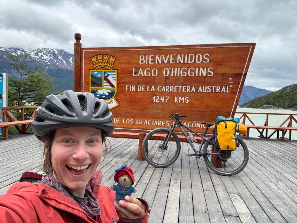
Villa O’Higgins.
Un pueblo remoto de apenas unos cientos de habitantes, enclavado entre montañas y lagos. Es el extremo sur de la Carretera Austral. No hay caminos más allá de este punto.

DÍA 26: Día de descanso en Villa O'Higgins
Has llegado al final del camino, pero hoy te tomas el tiempo para sentirlo de verdad. Villa O'Higgins no es solo un pueblo al final de la ruta más emblemática de Chile; es una puerta de entrada. Un lugar para hacer una pausa, reflexionar y prepararse para lo que viene.
Hoy es un día de descanso, pero aún queda un recorrido que vale la pena hacer: los últimos 7 kilómetros al sur del pueblo, hasta el cartel oficial de fin de camino que marca el verdadero final de la Carretera Austral. Es un viaje corto pero significativo: toma una foto, respira hondo y recuerda este momento.
De vuelta en el poblado, hay mucho que explorar:
– Excursiones a glaciares en barco o a pie, especialmente al cercano Glaciar Mosco.
– Vistas del vasto Campo de Hielo Patagónico Sur, si el cielo está despejado.
– Una oportunidad para conocer a otros viajeros de todo el mundo: senderistas, ciclistas y viajeros por tierra convergen aquí.
Si alquilaste tu bicicleta en Austral Bikes, también podrás entregarla hoy.
Si utilizaste el servicio de envío de mochilas de Austral Bikes, tu mochila te estará esperando allí mismo, la enviamos cuando la dejaste en Puerto Varas.
DÍA 27: De regreso a casa o cruzando a Argentina
Hoy es tu último trayecto: un día de reflexión, transición y decisión. Tras llegar a Villa O'Higgins, te encuentras en una encrucijada en el camino. Para muchos, es hora de volver a casa. Para otros, es hora de seguir adelante, adentrándose en la naturaleza de Argentina.
Opción 1: El viaje de regreso
Si regresas a la región central de Chile o vuelas al extranjero, tu regreso comienza aquí. Desde Villa O'Higgins, deberás tomar un bús a Cochrane, un largo pero pintoresco recorrido por los mismos paisajes impresionantes que recorriste en bicicleta. En Cochrane, deberás tomar otro bus que te llevará Coyhaique, el aeropuerto de Balmaceda, queda cerca de Coyhaique.
El viaje de regreso puede durar de dos a tres días, dependiendo de las conexiones, el clima y la disponibilidad de buses, por lo que es importante planificar y reservar con antelación siempre que sea posible. Muchos viajeros optan por dividir el viaje con una noche en Cochrane o Coyhaique antes de volar.
Opción 2: Cruzar a Argentina
Para los más audaces y aventureros, existe otra ruta que continúa hacia el sur. Desde Villa O'Higgins, se puede cruzar a Argentina mediante un viaje de varias etapas que incluye paseos en barco, senderismo y trámites fronterizos.
Comenzarás organizando un viaje en barco por el Lago O'Higgins hasta Candelario Mancilla. Desde allí, tendrás que hacer una caminata de 22 kilómetros por senderos forestales remotos para llegar al Lago del Desierto, y luego otro barco para llegar a El Chaltén y El Calafate.
Este cruce solo se recomienda para viajeros experimentados con equipo ligero, buena planificación y espíritu de aventura. El clima, los horarios de los barcos y las condiciones de los senderos pueden influir en la experiencia, pero es uno de los cruces fronterizos más singulares y remotos del mundo.
